DroNE SURVEYING: Insite
ST. MODWEN
Hendrefoilan Park, Swansea
Tracking a site in transition through repeatable survey data
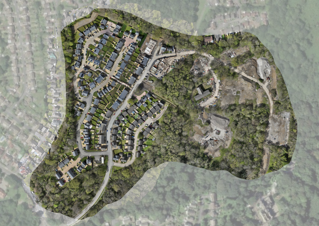
Hendrefoilan Park is the latest feature in our Insite series, a monthly look at live developments and the role survey data plays in helping teams understand progress, manage change and make better decisions on site. We began surveying Hendrefoilan Park in December 2024, at a stage where demolition had already taken place and the development had moved into active groundworks and early construction. Since then, our surveys have created a consistent visual and measurable record of how the site has evolved as later phases have taken shape and homes have moved into the sales market.
A site with a past
Before it became Hendrefoilan Park, this site was known to generations of Swansea students as Hendrefoilan Student Village, or simply HSV, sometimes just “The Village”. Built up over several decades from the 1970s onwards, it was a familiar part of the local landscape and a place with its own identity, routines and footprint. That matters, because developments like this do not begin from a blank sheet. Even once buildings are removed, the legacy of the previous site remains in levels, access routes, buried infrastructure and the overall way the land has been used.
HSV closed in June 2023, and the site then moved fully into redevelopment. By the time we started surveying in December 2024, Hendrefoilan Park had already shifted beyond demolition and into active delivery. From that point on, the value of repeatable drone surveys was not in documenting a before-and-after headline, but in building a reliable timeline of what was actually happening as the development moved forward.
Insite Insight
Brownfield sites do not reset to zero
Demolition removes buildings, but it does not remove what sits beneath them. Old foundations, service runs, made ground and historic level changes all remain, and they continue to affect how the site behaves.
On a live development, those conditions show up in earthworks, drainage and build levels. If they are not picked up early, they tend to surface later as programme or cost issues.
Having consistent survey data allows teams to see how those conditions are playing out across the site, and to deal with them while they are still manageable.
What our survey timeline shows
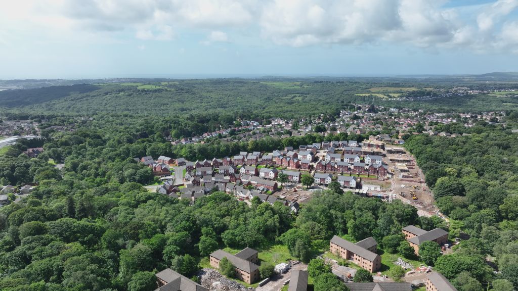
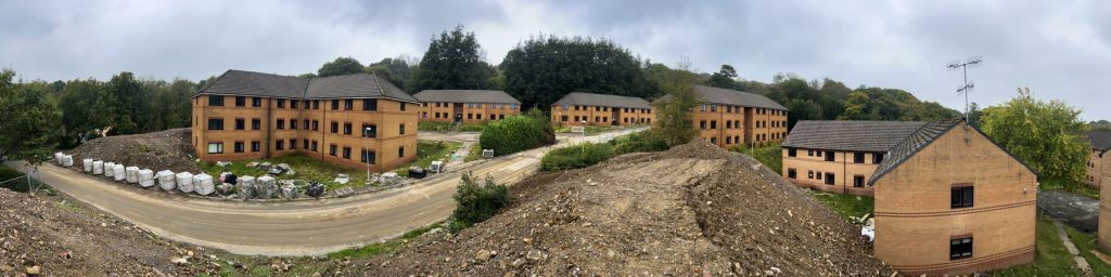
Since December 2024, each survey has added another layer to a growing record of the site. In the earliest datasets, Hendrefoilan Park is still strongly defined by groundworks. The shape of the development is there, but large areas remain open, infrastructure is still bedding in, and the balance of the site is weighted towards preparation rather than completion. As the timeline moves through 2025, that balance changes. Road layouts become more legible, plot formation becomes more consistent, and vertical construction starts to dominate a greater proportion of the footprint.
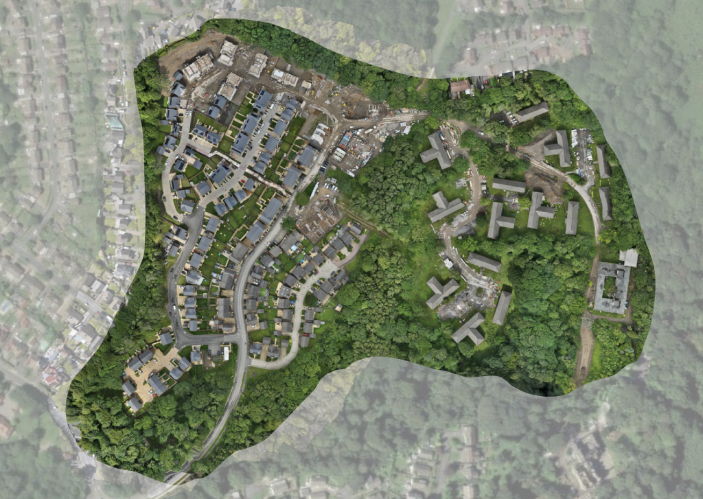
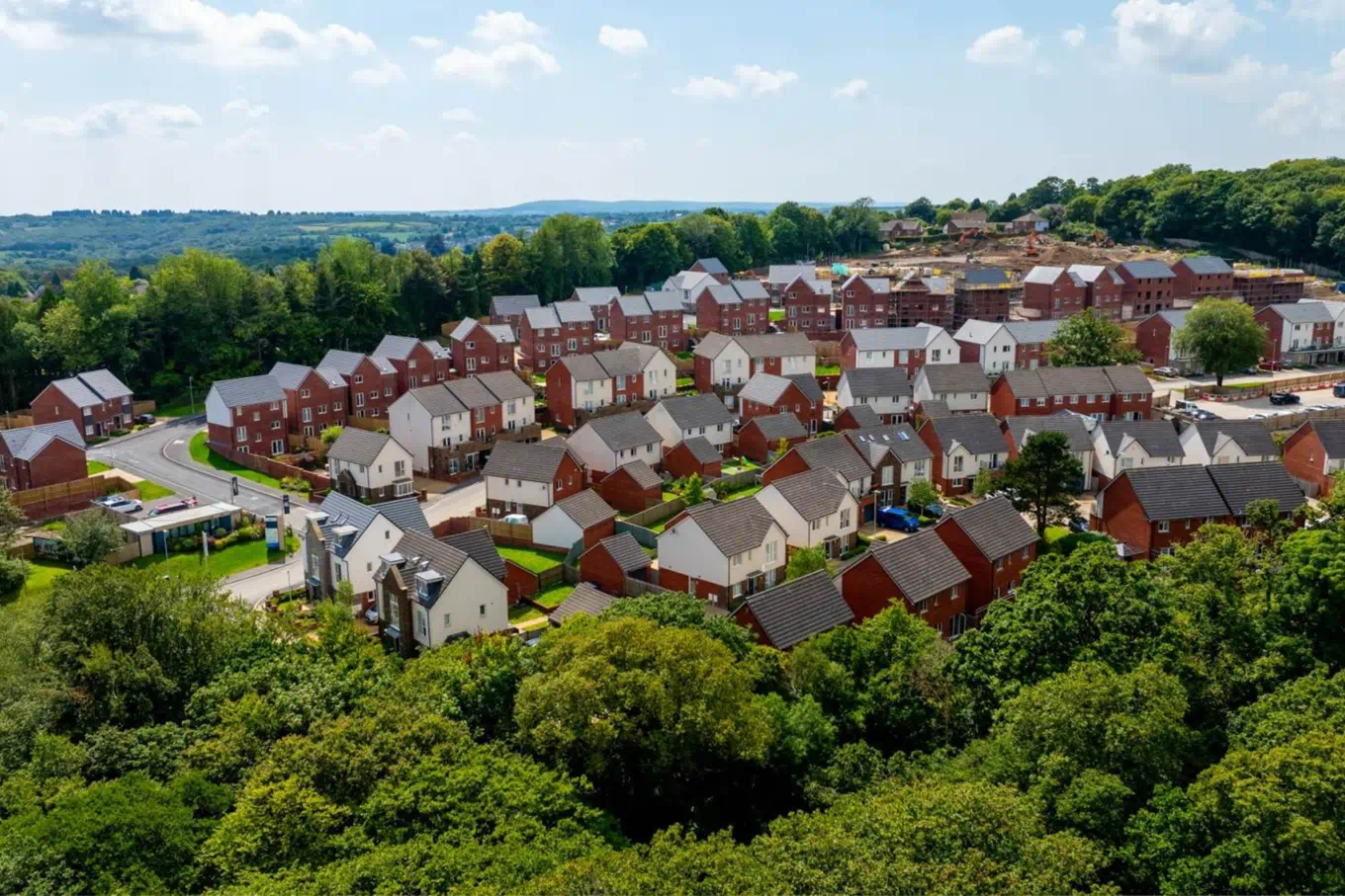
Later surveys show the development taking on a different character again. Streetscapes begin to read more clearly, completed homes sit alongside active phases, and the site starts to function not just as a build, but as a place that is being presented and sold. This is one of the reasons a timeline matters. A single aerial image can be impressive, but a repeatable sequence of surveys shows context. It shows how the development is moving, where attention is shifting, and how different phases relate to one another across the whole site.
Insite Insight
Progress is rarely linear
On phased developments, one area may be nearing completion while another is still in early works. Repeat surveys make it easier to understand that relationship across the site rather than judging progress from isolated viewpoints.
More than progress tracking
The visual side of drone surveying is often the easiest thing to understand, but it is only one part of the value. What matters more is that each survey produces a measurable site model that can be used in ways that support delivery far beyond a monthly progress image. On developments like Hendrefoilan Park, this means creating a dataset that can help teams interrogate the site, compare conditions over time and make decisions using evidence rather than assumption.
Material management is a good example. Stockpiles can be measured directly from survey data, giving teams a clearer understanding of how much material is available on site and how it is being moved or reused as different phases progress. On large developments, where material is not always staying in one place for long, that visibility helps support tighter control and fewer surprises. It is one of the reasons our work increasingly overlaps with value engineering and materials management, rather than sitting purely in the world of reporting.
The same applies to cut and fill analysis. By comparing surveyed ground levels against design intent, teams can understand where material needs to be cut, where fill is required and how those movements can be balanced more effectively. On a fast-moving development, that kind of clarity supports practical decisions that affect programme, haulage and cost.
Survey data can also be overlaid with design information. Using CAD overlays, proposed layouts, levels and infrastructure can be viewed directly against the live site, making it easier to sense-check whether reality matches expectation. This is particularly useful where conditions on site are evolving or where assumptions made earlier in the project need to be tested against what is actually there.
That is where the wider role of drone data becomes more useful. It is not just about producing attractive aerials or showing that a site has changed since the last visit. It is about creating a dependable reference point for decision-making. That could mean understanding site levels more clearly, reviewing the relationship between phases, checking measurements from the office, or combining visualisation with design data to reduce uncertainty before it becomes a problem.
Stockpile measurement
Understand material volumes on site and how they are changing over time.
Cut and fill planning
Compare live conditions with design surfaces to support better earthworks decisions.
CAD overlays
Sense-check layouts, levels and infrastructure against the surveyed site.
Value engineering
Use accurate site data to reduce uncertainty and support more informed choices.
Why this matters on a live development
On a live housing development, information does not just sit in one place. Site teams, commercial teams, technical teams and office-based decision-makers all need to understand what is happening, often at speed and often without being in the same location. Up-to-date survey data helps bridge that gap. Measurements can be taken directly from the dataset. Areas can be reviewed remotely. Questions can be answered with reference to something shared and measurable.
That shared understanding is part of what makes repeat surveys so useful. They create a common reference point. Rather than asking people to interpret what they think they saw on site, they allow teams to review the same environment from the same dataset. On a phased development, where conditions can shift quickly, that kind of clarity is valuable.
Insite Insight
Better site data supports better site decisions
The real value is not in the drone flight itself. It is in what the resulting data allows teams to understand, test, measure and act on afterwards.
A stronger picture of the site
Hendrefoilan Park is a good example of why this matters. It is a site with a previous life, a site moving through phased delivery, and a site now progressing into a more mature stage where completed homes and active construction sit side by side. Looking at a development like that through a single lens is not enough. A site plan will not show everything. A site visit will only ever capture a moment. A repeatable survey timeline, backed by measurable data, provides a far richer understanding of how the site is really changing.
That is what Insite is about. Not just showing a site from above, but using survey data to see it more clearly.
Explore related pages
To see more of how we support housebuilders and groundworks teams, explore our services, read how it works, browse our projects and case studies, or find out more about our work in 3D modelling, photogrammetry and improving planning and design.
Insite
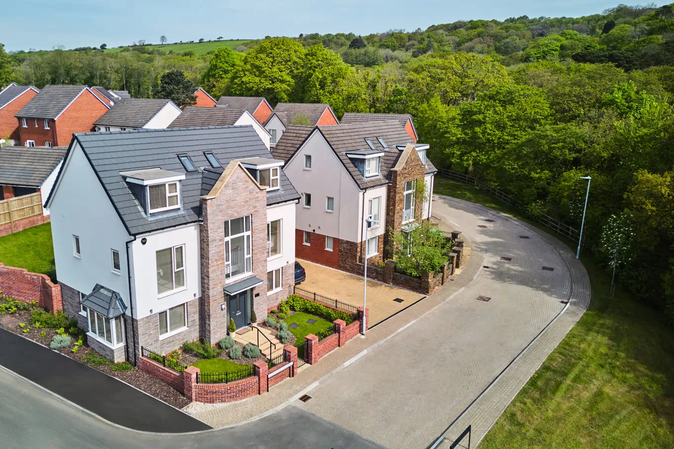
A development taking shape
As the site moves into its next phase, it’S worth looking at what is now being delivered and brought to market.
What becomes increasingly clear through the survey timeline is not just how Hendrefoilan Park is progressing, but what it is becoming. This is now a development moving through active delivery into a more established residential setting, with completed homes, infrastructure and later phases all sitting alongside one another.
St. Modwen is currently marketing a new phase of 2, 3 and 4 bedroom homes at Hendrefoilan Park, with the development positioned in the desirable Swansea suburb of Killay / Sketty, less than four miles from Swansea city centre and within easy reach of shops, restaurants, schools, coastline and countryside. That matters because it shows the site not just as a build programme, but as a place that is now taking on its long-term identity.
Location
Sketty / Killay, Swansea
Set in the leafy suburbs of Swansea, with city access, local amenities and the coastline all close by.
Current phase
2, 3 & 4 bedroom homes
A new phase is now being promoted, reflecting how the development has moved into a more mature stage.
Guide price
From £269,995
Pricing and availability change, so readers can check the latest releases directly on St. Modwen’s website.
Insite Insight
A site is more than its build programme
There is a point where a development stops reading purely as a construction site and starts to feel like a place people will actually live. Viewed over time, that shift becomes much easier to see.
A closer look at what is being delivered
St. Modwen describes Hendrefoilan Park as part of a wider regeneration project, turning the former student accommodation site into a neighbourhood with public open spaces and natural walkways. It also highlights local schooling, nearby amenities and strong connections into Swansea and beyond.
That wider context is useful in a piece like this because the survey timeline shows exactly how the physical site is moving towards that outcome. Roads, plot build-outs and completed homes are no longer abstract elements of a site plan. They are becoming part of a live residential setting.
Readers who want the latest house types, availability and site layout can explore the development directly through St. Modwen’s own page.