
The innovative surface run-off tools within our client portal enable you to quickly visualise how heavy rainfall or flowing water will affect your worksite above and below the ground, based on the current topography and terrain.

A high-definition 3D model providing detailed architectural data of the demolished Crooked House pub has been discovered in our drone archives. The 3D scan of what was dubbed ‘Britain’s wonkiest pub’ in Himley could prove invaluable in helping to ensure it is accurately recreated after council planners ordered the owners to rebuild it within three years.

Drone surveys have become increasingly popular in a wide range of industries, including construction, agriculture and mining. The use of drones for surveying has revolutionised the house building industry, providing more accurate and detailed data in comparison to more traditional surveying methods. Here’s how it works, from start to finish, along with details on who the data benefits.

The use of drone surveys has brought a new era of accuracy and detail to a range of industries, including construction, agriculture and mining. The house-building industry in particular has been transformed by this technology, which is quickly making traditional surveying methods a thing of the past.

In today’s rapidly evolving construction industry, staying ahead of the curve requires innovative solutions that streamline processes, enhance accuracy, and drive cost savings.

How DRONE SURVEYING can help bring construction issues to light

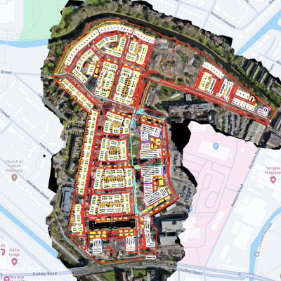
I have worked with DRONE SURVEYING for some years now, from checking a boundary of new land to auditing earthworks. The use of drones on our sites is now standard; we monitor progress and calculate cut and fill via the online software as our sites progress.

The use of regular mass data collection and the latest drone technology and practises will without doubt save us time and money on our sites.

We use DRONE SURVEYING on all of our sites to support our cut and fill strategy, with regular surveys and their cutting-edge software, we are able to manage our sites much more effectively.

Having now worked with DRONE SURVEYING engineering solutions for a number of years, their services have proven to be invaluable conducting our volumetric surveys, progress videos and cut and fill support. The drone data platform has allowed us to get the best from the data with full support and training provided from the DS team

The drone data helps us to make quicker and smarter key decisions to ensure we have budget and time control on our projects. Having monthly surveys on our sites ensures we keep full control of all earth movements.

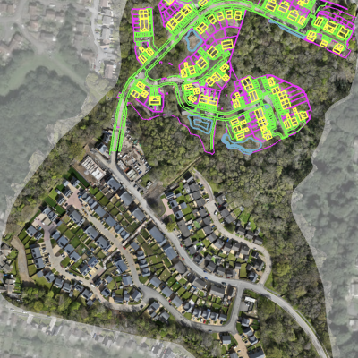
Using aerial imagery from drone surveys helps us anticipate errors or mistakes in the next stage of development instead of waiting for work to start on the ground. This proactive approach has saved us hundreds of thousands of pounds; a reactive approach can be costly