
Drone Surveying: Insite
VISTRY
Former Birmingham City Hospital Regeneration
Surveying the start of a major brownfield transformation in Birmingham
The former Birmingham City Hospital site is the latest feature in our Insite series, a monthly look at live developments and the role survey data plays in helping teams understand progress, manage change and make better decisions on site. Drone Surveying carried out an initial survey on 20 April 2026, capturing the early stages of one of Birmingham’s most significant brownfield regeneration projects.
A landmark site entering a new chapter
Few development sites carry the same civic weight as a former hospital. For generations, Birmingham City Hospital was part of the fabric of the city, serving communities from its Dudley Road site and becoming a familiar landmark in Winson Green.
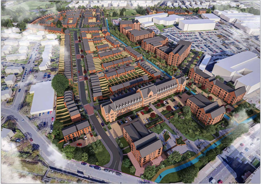
The site is now being brought forward by Vistry in partnership with Homes England, with plans to deliver approximately 750 new homes. The scheme includes the demolition of most existing hospital buildings to provide new housing, alongside the conversion of the historic infirmary building into apartments.
That combination of demolition, retained heritage, new infrastructure and mixed-tenure housing makes this a complex site from the outset. It is not simply a cleared plot awaiting development. It is a major urban regeneration site with a long previous use, existing constraints and a prominent role in Birmingham’s next phase of housing delivery.
Insite Insight
Regeneration projects carry more than physical constraints
When a site has served a community for generations, redevelopment is about more than replacing buildings. Historical land use, existing infrastructure, retained structures, planning requirements and stakeholder expectations all influence how the project progresses.
Survey data helps create a clearer record of that transition, showing how the site changes from its former use into a new residential neighbourhood.
A 750-home brownfield regeneration project
The redevelopment will deliver around 750 homes across a mix of tenures. Vistry has confirmed delivery partners including Midland Heart, which will own and manage affordable homes, and Leaf Living, which will deliver homes for the private rented sector.
The scheme also includes a retail convenience store and the conversion of the former infirmary building into 52 one and two-bedroom apartments. The result is a development that will not only reuse a prominent brownfield site, but create a new residential community in an established part of Birmingham.
From a survey perspective, this is exactly the type of site where an early, accurate record matters. Before construction reaches full momentum, the initial dataset provides a clear reference point for what was present, how the site was arranged, and how early works were progressing.
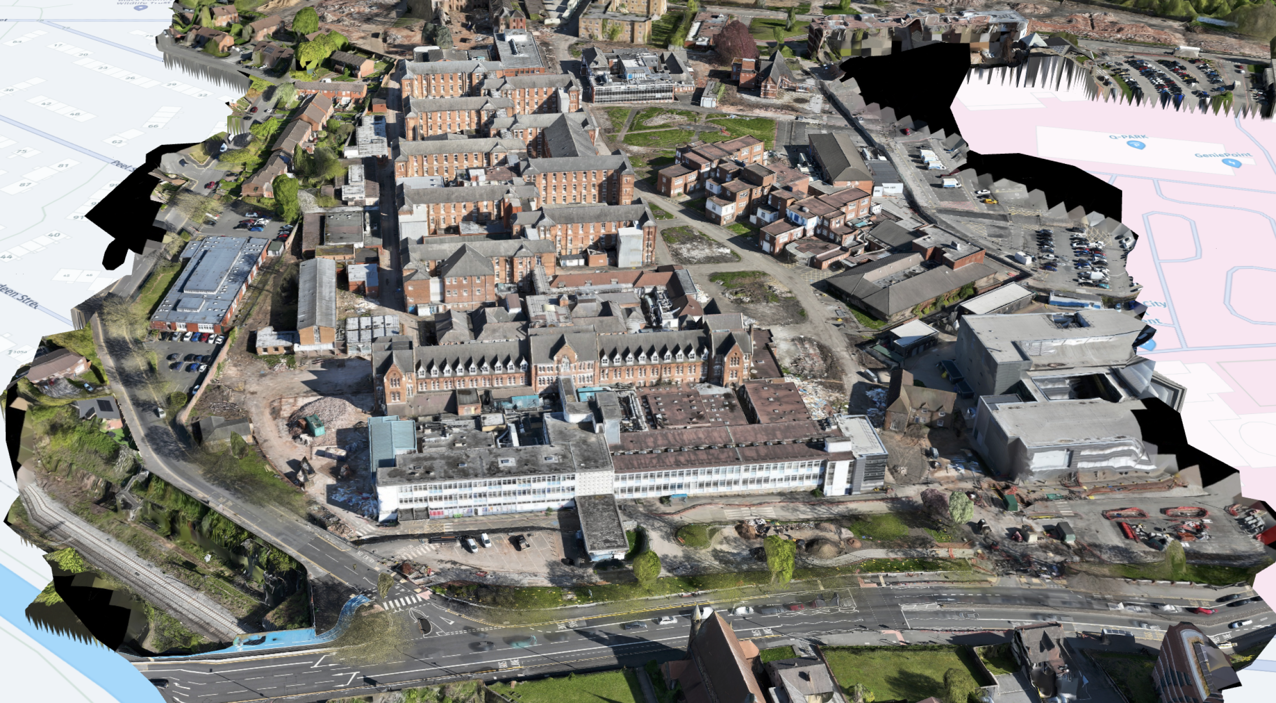
Our first survey: 20 April 2026
Drone Surveying carried out an initial survey of the former Birmingham City Hospital site on 20 April 2026.
That makes the first survey particularly important. It establishes a clear early-stage record of the site as redevelopment begins, providing a measurable reference point that can be used as future surveys are captured and the project moves forward.
On a major brownfield site, this early record can become valuable very quickly. As buildings are removed, levels change, materials move and access routes adapt, the original survey provides a way to understand what has changed and how those changes relate to the wider development plan.
Insite Insight
The first survey is the reference point
A single survey may not yet show a timeline, but it creates the baseline from which the timeline begins. On a site of this scale, that first record helps future progress be understood in context.
Flying in restricted airspace
The former Birmingham City Hospital site also presented an important operational consideration due to its proximity to HMP Birmingham. Operating in this environment required additional planning and permission before any drone activity could take place.
Insite Insight
Safe, compliant flying around sensitive sites
Operating drones in urban environments often involves more than simply arriving on site and flying. Proximity to sensitive locations, including prisons, requires careful planning, appropriate permissions and a clear understanding of the airspace environment.
For this survey, the site’s location near HMP Birmingham meant additional checks and permissions were required before the flight could be carried out. These steps are not always visible in the final survey outputs, but they are a critical part of delivering safe and professional drone operations.
This is especially important on major regeneration sites, where survey data needs to be captured without disrupting the wider environment or compromising safety, security or compliance.
More than progress tracking
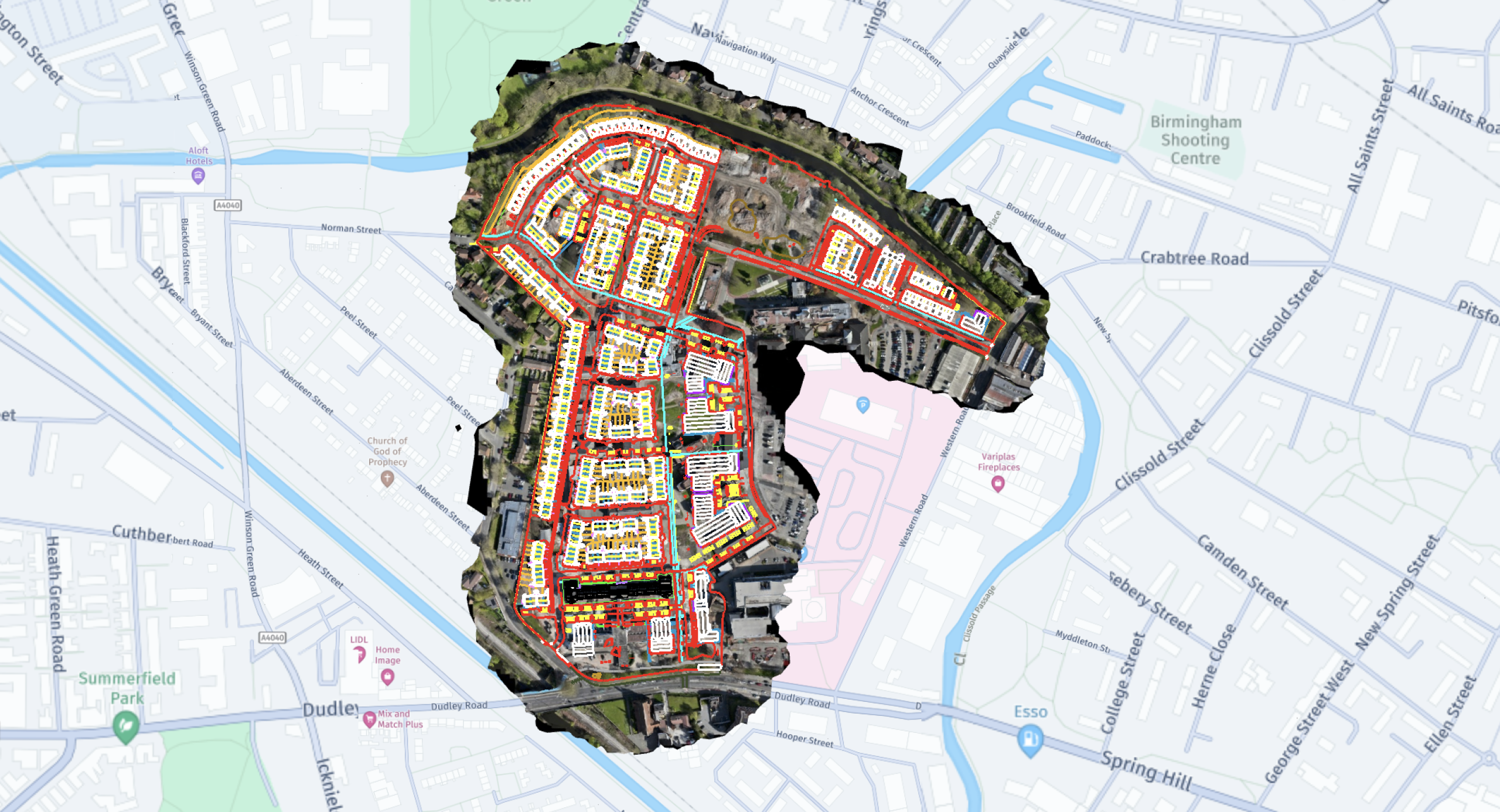
The visual side of drone surveying is often the easiest thing to understand, but it is only one part of the value. What matters more is that each survey produces a measurable site model that can be used in ways that support delivery far beyond a progress image.
On a site like the former Birmingham City Hospital redevelopment, survey data can support a wide range of practical uses. It can help teams understand existing levels, monitor material movement, measure stockpiles, compare progress against design information and review the relationship between different areas of the site.
Material management is one example. Stockpiles can be measured directly from survey data, giving teams a clearer understanding of how much material is available on site and how it is changing as works progress. On a large brownfield development, where material can be stripped, stored, reused or removed, that visibility supports better control.
The same applies to cut and fill analysis. By comparing surveyed ground levels against design intent, teams can understand where material needs to be cut, where fill is required and how movements can be balanced more effectively.
Survey data can also be overlaid with design information. Using CAD overlays, proposed layouts, levels and infrastructure can be viewed directly against the live site, helping teams sense-check whether what is happening on site aligns with the intended design.
Together, these uses contribute to a broader process of value engineering. Accurate survey data gives teams a stronger basis for decisions, helping reduce uncertainty before it becomes a programme or cost issue.
Stockpile measurement
Understand material volumes and how they are changing over time.
Cut and fill planning
Compare live site levels with design surfaces to support earthworks decisions.
CAD overlays
Review proposed layouts, levels and infrastructure against surveyed conditions.
Value engineering
Use accurate site data to reduce uncertainty and support informed decisions.
A site moving from hospital to neighbourhood
One of the most interesting aspects of this project is the change in purpose. For many years, this was a place people visited for healthcare. It is now being transformed into a place where people will live.
That shift is significant. Roads, homes, open space, retained heritage and new infrastructure will all need to come together to form a functioning residential community. Survey data helps capture that change as it happens, giving teams a clearer view of how the site is evolving from its former use into its future role.
Insite Insight
A site is more than its build programme
There comes a point where a development stops being viewed purely as a construction project and starts becoming a place. Survey data helps capture that transition, showing not just progress, but the emergence of an entirely new community.
Development snapshot
Client
Vistry
Location
Former Birmingham City Hospital, Dudley Road
Development
Approximately 750 new homes
Survey date
20 April 2026
Site type
Urban brownfield regeneration
Operational note
Additional permissions due to proximity to HMP Birmingham
Further reading
The former Birmingham City Hospital redevelopment has been covered in detail by Vistry, Homes England and the construction press. These articles provide further background on the project, partnerships and delivery plans.
Vistry: work starts on 750-home regeneration
Homes England: building lease announcement
Vistry & Homes England partnership
Explore related pages
To see more of how we support housebuilders and groundworks teams, explore our services, read how it works, browse our projects and case studies, or find out more about our work in photogrammetry, 3D modelling and value engineering.
A stronger picture of the site
A site visit captures a moment. A survey timeline captures a story.
For projects like the former Birmingham City Hospital regeneration, that difference matters. Repeatable survey data provides context, clarity and measurable insight throughout the construction process, helping teams understand not just what the site looks like today, but how it is evolving over time.


