


Drone Surveying: FIELDNOTES
BIN THERE, NOT DONE THAT…
A comparison between the latest drone survey and the supplied site layout identified two refuse collection points shown within the design – but apparently missing from the completed street.
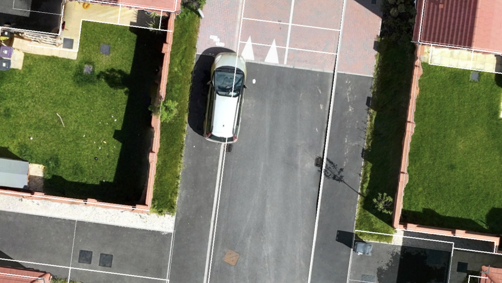
The section of road appeared substantially complete. The carriageway, driveways, plot boundaries and landscaped areas were all clearly visible within the latest orthomosaic. When the site layout was overlaid onto the survey, however, two small rectangular features stood out, that would easily be missed with a walk-around check.
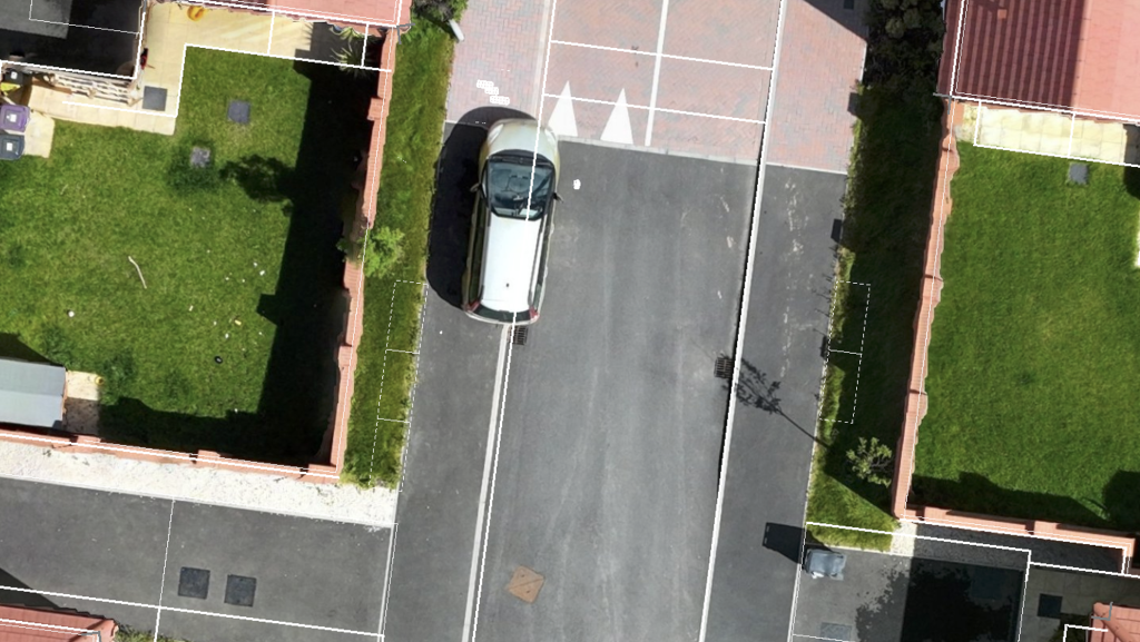
The drawing showed a refuse collection point on either side of the road, positioned within the grassed verges beside the completed plots. In the current survey, both designated areas appeared to have been finished as grass, with no corresponding hardstanding visible.
Viewed without the design, the verges appeared complete and consistent with the surrounding landscaping. It was only when the relevant CAD layer was displayed over the georeferenced survey that the two missing features became apparent.
The white dashed outlines showed where the refuse collection points were indicated on the site layout. The latest survey showed grass occupying both positions, with no hardstanding visible within either footprint.
Why the Missing Collection Points May Matter
Refuse collection points are relatively small features within the wider development, but their position and construction can affect how bins are presented and collected once the plots are occupied.
A designated hardstanding can provide a stable, identifiable location for containers on collection day, keeping them away from private driveways, landscaped areas and the carriageway. Depending on the approved layout and local authority requirements, it may also form part of the agreed waste-management arrangements for plots that cannot present bins directly at the kerb.
If these collection points remain part of the approved highway, planning or waste-management design, their absence could become an issue during inspection, adoption or handover.
Where the features fall within works covered by a Section 38 agreement, the local highway authority may compare the completed street with the approved drawings before accepting it as publicly maintainable highway. Missing works can be raised as adoption snags and may need to be completed before the relevant certificate is issued.
The likely consequence would be a requirement to clarify the approved arrangement or complete the missing works before the road progresses through adoption.
By that stage, however, the verges may already have been landscaped and the surrounding plots occupied. Installing the hardstandings could then require completed turf and topsoil to be removed, contractors to return and an otherwise finished area to be reopened.
The survey cannot determine why the collection points were absent. They may have been omitted during construction, removed through an approved design change or included within a revised drawing that was not supplied for the comparison.
What the data provides is clear evidence of a difference between the completed street and the drawing being reviewed, allowing the site and technical teams to establish which information is current before the discrepancy reaches a later inspection or adoption stage.
Small Features Are Easily Lost Within the Wider Site
A residential layout contains hundreds of individual details. Against plots, roads, drainage, boundaries and major areas of public open space, two small refuse collection points can be easy to overlook.
From ground level, there may be no obvious indication that anything is missing. A neatly finished grass verge looks complete, particularly once the surrounding plots and external works have progressed.
The CAD overlay changes the context. It places the intended features directly over the current site record, making it possible to see not only what has been constructed, but what the drawing indicates should occupy a particular position.
This is where the distinction between capturing a site and reviewing it becomes important. The orthomosaic recorded the grassed areas accurately; the design comparison revealed why those areas warranted closer attention.
Identifying Adoption Snags Earlier
Highway adoption involves more than completing the road surface. The local highway authority may inspect the adoptable works against the approved drawings and relevant specification before issuing the certificates required for adoption.
Where something is missing or differs from the approved design, the authority may require further information, an approved amendment or remedial work before the process can move forward.
Not every discrepancy will affect adoption. The collection points may fall outside the adoptable highway, or a revised arrangement may already have been agreed. That is why the survey identifies the difference without attempting to determine its contractual or regulatory significance.
Its value lies in giving the project team an opportunity to check the position before formal inspections, completed landscaping or occupation make the issue more disruptive to investigate.
In this case, two dashed rectangles within the CAD layer were enough to reveal that features shown on the layout were not visible within the completed street.
Checking the Detail with CheckPoint
This is the purpose of our CheckPoint service. Rather than allowing survey data to remain a passive record, CheckPoint provides a structured review of the latest site information against the relevant drawings and previous surveys, highlighting potential snags that may warrant closer attention.
On sites we survey regularly, this ongoing review is particularly valuable. Smaller features can be checked as roads, plots and external works progress, allowing apparent omissions or differences to be investigated before landscaping, occupation or adoption makes them more difficult to address.
What might be missing from your latest survey?
Drone Surveying helps housebuilders compare current site conditions with engineering and layout information, giving technical, commercial and construction teams a clearer understanding of how the development is progressing against design.
Through our CheckPoint service, regularly surveyed sites benefit from an additional layer of review designed to identify potential snags while there is still time to investigate them—before they emerge during handover or adoption.
Discover more about CheckPoint and our drone surveying services


